

Aerial imagery#
Aerial workflows start from a georeferenced raster: a drone orthomosaic you
already have, or a basemap that rAPIdtools stitches for you from Bing or
Google tiles. AerialImageryExtractor then
crops one patch per asset from that raster and attaches it to the asset.
Cropping an orthomosaic around each asset#
from rapidtools import AerialImageryExtractor, PhysicalAssetCollection

buildings = PhysicalAssetCollection.from_geojson('buildings.geojson')
extractor = AerialImageryExtractor(
    dataset='ortho.tif',                # a TIFF, a folder of TIFFs, or a list
    save_directory='output/crops',
    buffer_m=10,                        # margin around the footprint
    force_square_image=True,
    image_prefix='post_disaster',
)
buildings = extractor(buildings)
buildings['bldg_01'].image_assets[0].properties['wgs84_bounds']
Each crop is saved as a JPEG named after the asset centroid and attached as
an ImageAsset whose properties record the crop’s
WGS84 bounds and the source raster. When dataset is a folder, every
raster is opened once and only the assets inside its extent are processed,
so regional mosaics split across many files work without extra code.
Sizing the crop#
buffer_asset accepts a percentage of the asset’s extent ('20%', the
default), a real-world distance ('10 m', '30 ft') or a bare number in
the raster’s units; buffer_m is a shortcut for metres. With
force_square_image=True every crop covers a square area on the ground,
which keeps aspect ratios consistent for the model.
Assets on the edge of the imagery#
Coverage is judged from the raster’s own mask, so nodata values, alpha bands
and internal masks all count. By default a crop is skipped when more than
max_missing_data_ratio (20 %) of it is empty. For assets that straddle
the edge of a flight, switch to a footprint-based test instead:
AerialImageryExtractor(
    'ortho.tif', save_directory='crops',
    min_footprint_coverage=0.3,   # keep if 30 % of the footprint is imaged
    pad_edges=True,               # pad with nodata so crops keep their size
)
Outlining the target asset#
Dense neighbourhoods are where a model most often describes the wrong
building. overlay_asset_outline=True draws the asset onto the crop so the
prompt can refer to “the outlined building”. The outline’s shape, offset,
stroke and colour are configurable:
AerialImageryExtractor(
    'ortho.tif', save_directory='crops', buffer_m=8,
    overlay_asset_outline=True,
    outline_shape='corners',     # 'geometry' | 'bbox' | 'rotated_bbox' | 'convex_hull' | 'corners'
    outline_buffer='2 m',        # push the outline away from the asset
    outline_width='1%',          # of the shorter image side, or pixels
    outline_color='#00ffff',
)
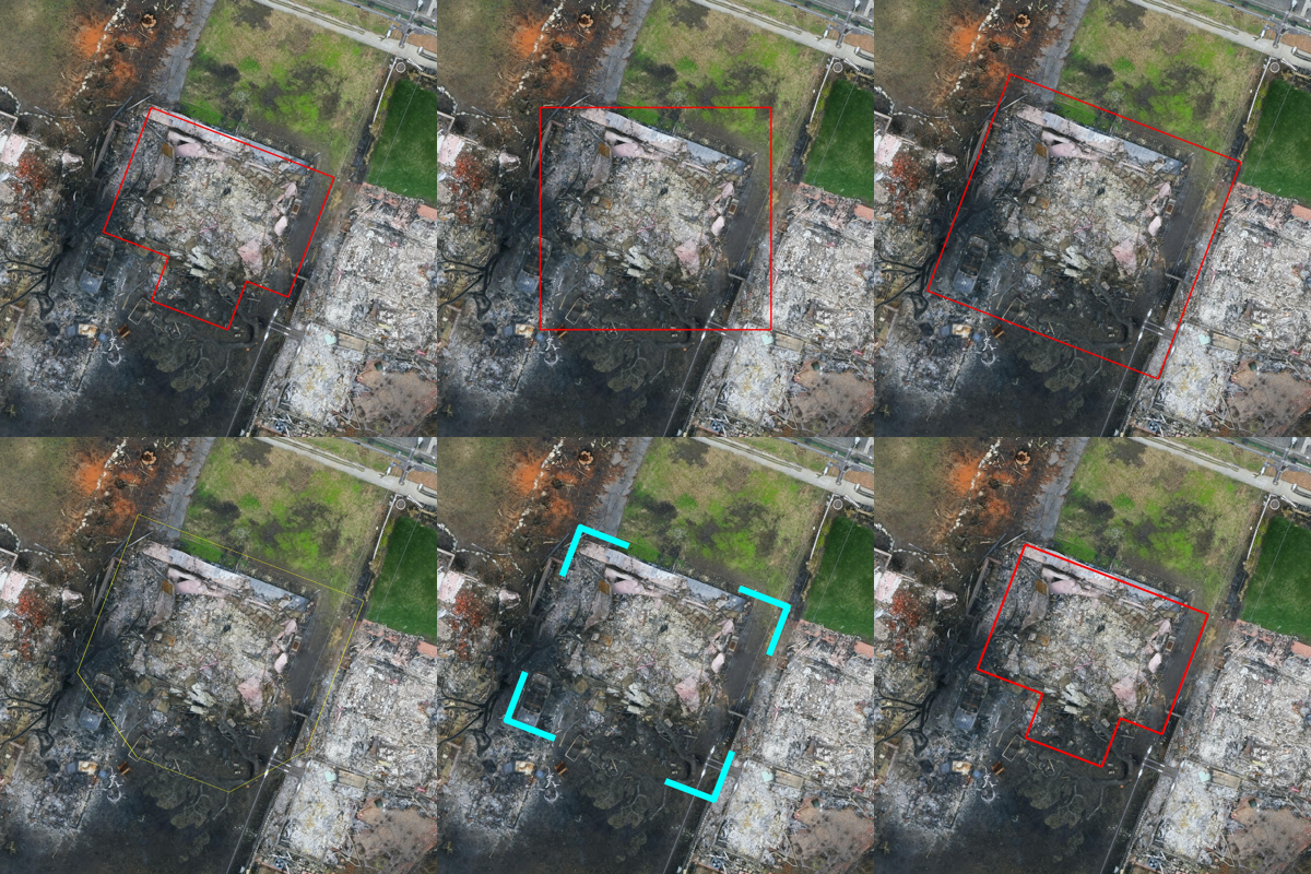
One building from the Eaton Fire orthomosaic. Top row: the footprint itself, its bounding box, and a rotated bounding box pushed out by 2 m. Bottom row: a convex hull with a thin yellow stroke, cyan corner brackets, and the footprint with a stroke scaled to the image.#
Corner brackets are worth trying for damage assessment: a closed line can
hide exactly the roof edge the model needs to see. Point assets are drawn as
a dot, or as a ring of radius outline_buffer when a buffer is set.
Basemaps without an API key#
When you have footprints but no flight, stitch a basemap for the area.
BingOrthomosaicExtractor and
GoogleOrthomosaicExtractor download tiles in
parallel and write a georeferenced GeoTIFF that every other component reads
like a drone orthomosaic:
from rapidtools import BingOrthomosaicExtractor, BoundingBox

region = BoundingBox.from_raster('eaton_patch_20250214.tiff')
tiff = BingOrthomosaicExtractor(zoom_level=19, max_workers=10)(
    region, output_path='eaton_bing.tiff'
)
Google’s servers go up to about zoom 21 in urban areas and offer a hybrid
layer with labels (layer='y'). These endpoints are the ones used by the
Google Maps web app; they are unofficial and may change, and every request
fails soft with a logged error.
Per-polygon satellite crops#
For a quick set of training images without a raster in between,
GoogleAerialImageExtractor and
BingAerialImageExtractor crop tiles
directly for every polygon in a GeoJSON file:
from rapidtools import GoogleAerialImageExtractor

with GoogleAerialImageExtractor('output/aerial', zoom_level=20) as aerial:
    paths = aerial.process_geojson(
        'buildings.geojson', buffer_percent=0.1,
        pad_to_square=True, resize_to=(640, 640),
    )
Reading rasters directly#
OrthomosaicReader is the low-level reader
behind the extractor. It opens a GeoTIFF once, reports its WGS84 extent,
crops a patch around any geometry with the same buffering rules, and slides a
window over the whole raster, skipping empty tiles:
from rapidtools import OrthomosaicReader

with OrthomosaicReader('ortho.tif') as reader:
    bbox = reader.get_mosaic_bbox_wgs84()
    for image, bounds in reader.generate_tiles(patch_size=50, unit='meters'):
        ...   # a PIL image and its (min_lon, min_lat, max_lon, max_lat)